 |
| Homes in Colorado Springs engulfed by Waldo Canyon fire on Tuesday, June 26, 2012. |
 | |
| Fire advancing on Colorado Springs driven by 65 MPH wings |
According to reports in the media, this fire's behavior has been very unusual. Most fires burn in one general direction, based on the prevailing winds. They also tend to burn uphill and only burn downhill when forced to do so. In this case, all of those generalities went away. The wind in the area is constantly changing directions and the map below shows the resulting fire progression.
After Tuesday's blowup, the weather began to cooperate and firefighters have been making steady progress on containing the fire. As of today, the fire is reported to be 55% contained and evacuations are being lifted to many areas. At the middle of last week, approximately 40,000 people had been evacuated from their homes.
In Woodland Park, where the Leos are spending the summer, we have been on pre-evacuation alert since the fire began. Last Wednesday the eastern part of town went to manditory evacuation as a result of the burning shown in green in the map above. The fire has come to within about a mile and a half of the city limits and about three miles from our location at Bristlecone Lodge. So all week we watched round the clock news reports and kept our unit ready to go on short notice. The map below shows the boundaries of the fire as of Friday morning. Woodland Park is in the top left of the map (between the labels "Div E" and "Div F" on the map).
By Saturday afternoon the mandatory evacuation for that part of Woodland park it applied to was lifted, returning everyone here to per-evacuation status. On Sunday, Rt 24, between Colorado Springs and Woodland Park reopened. The fire is still active and will be for a few weeks. Assuming that nothing takes an adverse turn, full containment is projected by July 16.
After spending the week on "fire watch", we decided to take a break on the weekend and resume our exploration of the fishing opportunities in the area. We headed out in search of The Dream Stream. "The Dream Stream" is a three mile section of the South Platte river between Spinney Mountain Reservoir and Elevenmile Reservoir. Here is how it is described on one of the local guide's website:
With a nickname like the Dream Stream, you know it has potential. Also known as Spinney Mountain Ranch, this three mile long Colorado tailwater section of the South Platte River is nestled in the windswept high mountain plain of South Park. Flowing out of Spinney Mountain Reservoir, meandering through prime big trout habitat, the river eventually flows into Eleven Mile Reservoir.
A classic Colorado tailwater, the fish and aquatic life in the Dream Stream enjoy fairly consistent year round temperatures. An abundance of scuds, midges, mayflys, and caddisflys make up the majority of the trout's diet. These trout will also feed on hoppers, trout fry, eggs, and even mice if the opportunity presents itself--not to mention all the food washed out of Spinney Mountain Reservoir!
The Dream Stream portion of The South Platte River is public, and has easy bank access making this section a very popular destination for Colorado fly fisherman. These trout that can grow to gargantuan proportions have learned how to avoid detection and humble even the most skilled anglers. That is not to say that they can't be caught . . .
Although unpredictable wind and weather combined with sometimes fussy fish scare many an angler away from The Dream Stream, the dedicated fly fisherman can experience some of the best days of trout fishing imaginable, catching multiple Spinney Mountain Ranch trophies in a single day!!!!
About an hours drive from our base in Woodland Park, we arrived at Spinney Mountain Reservoir State Park. At the park entrance we were informed that the lake rules are artificial lures only, can keep only one trout ( must be over 20 inches long) and keep all the pike you catch. Interesting!!
Touring the park we found we still have equipment deficiencies. Here are some shots of fishermen on the lake.
 |
| Float tube and pontoon armada |
We saw no one fishing from the bank or wading. The entire area of the lake was dotted with belly-boats, floats and pontoons. My Outlaw Assault just got moved up the priority list!!!!
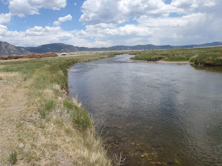
From the lake we headed below the dam and found the access point to The Dream Stream. We spent about an hour hiking along the stream and took these pictures.
 |
| The Dream Stream looking toward Spinney Mountain Reservoir |
After this tour, hiring a guide to learn how to fish this beautiful stretch of river just got moved up my list. Seems the list is getting crowded at the top. The hike also affirmed that during my trips to such locations to fly fish, the Trusty Companion will be a challenge. He is a natural explorer and gets excited by all he observes. This can range from chipmunks to birds to bugs to bison.
 |
| Bison herd on a ranch near Spinney Mountain Reservoir |
 |
| Post-hiking |
Till next time, we're here, Dreamin' in the Mountains.


