WELCOME

Welcome. The Two Leos (My Trusty Companion and I) are glad you stopped by. I have created this site to document and share our adventures as we travel around the United States. In 2011, these travels were limited to weekend outings and vacations. We used these to explore areas which will be visited more extensively in the future. Beginning in 2012, we expanded our travels as we transition to the full-time RV lifestyle. Check back from time to time to see our wanderings.

Quote

“...not all those who wander are lost...” Tolkien, J. R. R. (1954), The Fellowship of the Ring, The Lord of the Rings, Boston: Houghton Mifflin (published 1987), "Strider", ISBN 0-395-08254-4

Friday, August 19, 2011

Campgrounds and Back Roads

8-18-2011

Today we went back toward Taos, stopping in Mora at the Cowboy Cafe for a good breakfast. You have to be careful what you order. They seem to want to put New Mexico chiles in everything.

After breakfast we headed up into the Carson National Forest. I say “up” because it is a pretty steady climb from Mora.

Valley below Carson National Forest highway

About half way to Taos we found a real good Park Service Campground.

Campground entrance

River running through campground
 
The campground has a paved road and several pads that looked like they could handle a motorhome The park host had a Class C and another site had a Class C Plus parked. Other than that the site were open.


The road is pretty good


Leo seemed to really enjoy the view


From here we did some exploring of a couple of the Forest Roads. They are not as motorhome friendly. They are pretty good dirt roads but are narrow and I didn't find any place where it looked like you could turn a motorhome around. It looks like a toad will be essential. A bicycle won't cut it for me. A dirt bike would work, but a truck will be ideal.


No I didn't crash. I just put the camera down. We got back to camp safely mid-afternoon, in time to finish my book and slip in a nap. Ain't vacation great?

Cimarron Or Bust

8-16-2011

Today I made certain not to get lost. I accomplished this by following my new rule...travel with not particular destination in mind. It worked perfectly. When I got where I was going, I was there.

I started the day trip with a right turn from the state park entrance. Yesterday I went left and that got me lost immediately on my trip to Angle Fire. It turns out if you turn right, you wind up in Angle Fire about 30 minutes later. It's 17 miles from the state park in that direction. That means I averaged about 35 MPH. That seems about right. The speed limit seems to be 45 on most of the roads here, but there are many turns where you must slow down to 25 or less. Once again the scenery was great. Once I came out of the trees, the drive was through what I believe is called an Alpine meadow, surrounded by
mountains
Along road to Angle Fire


Angle Fire is a nice little resort town. I stopped at the Visitor Center and picked up some information. A nice lady there let me know that a new RV park is planned for next year with 300 sites. She also provided me with the password for their WiFi connection which I used to post my blog entries. I drove around town some and found that it is mostly hotels, condos, ski shops, T-shirt stores and such. Unlike Steamboat Springs, there didn't seem to be a “town” of Angle Fire, just a ski resort. But it did have WiFi and cell phone coverage so I could check in.

From Angle Fire we headed north and about 15 miles on we can to Eagle Nest. Eagle Nest's main attraction is Eagle Nest Lake. Like Angle Fire, the main focus of the town seems to be tourism.

Eagle Nest Lake

From Eagle Nest I headed toward Cimarron. From Eagle Nest to Cimarron is about 27 miles and a vertical drop from 8200 feet down to 6400 feet. It's a winding downhill run to Cimarron and a long climb back. This take you through Cimarron Canyon State Park. The Cimarron river flows from Eagle Nest Lake and, the highway runs along the river with pull-offs ever few hundred feet where you have access to the river.

Limit 1 over 16 inches! Then STOP.
 
So, it looks like a good place to fish, until you catch a keeper. Then you have to stop. Once you learn your way around this would probable be a good place to spend a few weeks.


Cimarron River along highway
 
In addition to the river the scenery in the State Park is spectacular.


Palisades Still

Driving through Cimarron Canyon State Park
 
Once I arrived at Cimarron, I found that it is little more than a wide spot in the road. By the time we got there it was 2:00 in the afternoon. So we grabbed a burger at the only place in town, then retraced our steps back to Coyote Creek.
 
Population 888
 
After this second full day of driving, I think we'll stay in camp tomorrow. Both Leos are getting pretty road weary.

We did get back in time to enjoy some nice evening sky at the campground.


Evening at Coyote Creek


8-17-2011

Today we stayed off the road. I read about two-thirds of a Louis L'Amore novel while Leo napped in his chair. We also took a walk along Coyote Creek and found a couple of beaver dams. 


Coyote Creek
 
While I was sitting on the bank a beaver came out and swam across his pool to gather some grass to carry home. I guess he was looking for lunch. Leo didn't see the beaver because he was busy trying to catch a grasshopper in a clover patch.

We had scattered rain throughout the day, so it was easy to just hang out. I've decided to scratch Valle Vidal off the list for this trip. It takes too long on these winding mountain roads to travel that far. We'd have to go Back to Cimarron again and then another 27 miles north. I think tomorrow we'll go back toward Taos and explore the National Forest some.

Tuesday, August 16, 2011

Accidental Taos

8-15-2011

It was a brisk morning today. I don't have a thermometer, but when Leo and I got up at 6:30 AM I'm guessing it was in the low 50s. Our sweaters felt good.

Good Morning Campers
 
I cranked up the propane stove and got some Starbucks VIA brewed. By 8:30 I realized that was an insufficient breakfast. I had seen a sign somewhere that said Angle Fire 20 miles. So I decided to make a run in to see if I could find a breakfast spot.

Two and one half hours and 75 miles later I rolled into Taos. When I got back to camp this evening I pulled out the map (which I'll take with me from now on) and determined where I went wrong. It seems I should have turned right instead of left at the State Park gate. That's what is known as getting' lost from the get-go. But I've come up with a sure fire way to avoid getting lost int future. From now on I'm going to explore with no particular destination in mind. That way no matter where I end up, it won't be accidental.

As it turned out, my accidental trip to Taos was great. It took me through a large section of the Carson National Forest. This offered some of the best scenery I've seen in years. Here is a sample:

View from the top of the drive through Carson National Forest.


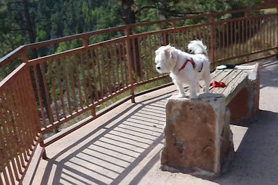
Leo found the prospect of chasing chipmunks down the mountain particularly tempting.

I hear movement in those leaves!!!!

Too bad that railing and Pappy are in the way.

On the trip through the National Forest I saw several NFS campgrounds that were sparsely occupied. There were also plenty of well marked NFS roads that I can explore for boondocking locations. Since this was my first time through this area and, remember, I started out going to breakfast in Angle Fire, I didn't venture off the main highway. You know, I wouldn't want to get lost. And while access is fairly easy, not many people venture past the first few miles of the stream, leaving the rest relatively pressure free.” I hope sometime when I out exploring with no destination in mind I can find Forest Road 438 off New Mexico Highway 518 and just happen to have my fly rod in the truck.

In the woods...

August 14, 2011

Coyote Creek State Park

It's evening on our first night here. After arriving mid-day, we got camp set-up and then collapsed for a three hour nap.

After that we headed back into Mora, NM to get gas for the truck. It really sucked it down pulling the trailer.

As we turned onto the highway from the state park entrance I immediately was stopped by a pedestrian crossing the road. It was a black bear headed over to the park for dinner.
When he saw our truck, he stopped and looked at us for a few seconds then turned around and headed back toward the direction he had come. I guess you could say, like Davy Crockett, I grinned him down. He's lucky Leo didn't see him or he may have been treed!! You know your in the woods when you see bears.

Hard Travelin'

August 14, 2011

The Leos are now on vacation in New Mexico. It's good to be out of the 100° plus Dallas heat for a few days. But getting here proved to be a bigger chore than I expected.

When we got up Saturday morning to load the truck and trailer, we were greeted with rain. It's the first rain we've had in over a month. So, by the time we were packed up and ready to roll, I was soaked with rain and sweat. It's a good thin T-shirts air dry well in the truck air conditioner.

We hit the road about 9:30, headed for an overnight at Caprock Canyons State Park. According to Google maps the trip is 315 mile and 5 hours and 31 minutes. This is slightly longer than my target maximum daily travel of 250 miles/5 hours.

I managed to miss a turn north of Fort worth due to construction and didn't realize it till I saw a sign telling me Denton and Oklahoma City were straight ahead. Since Wichita Falls is not in that direction, I pulled out my GPS and go myself back on track.

The next few hours were filled with the the beautiful scenery of northwest Texas.....flat...dry....straight road....oh, my achin' back (and hip and knee and neck)!!!


After missing a turn in Quitaque due to poor signage and having to backtrack 20 minutes, we finally arrived at Caprock Canyons State Park at 5:15. Let's see...that's 7 hours and 45 minutes. Due to poor navigation, 385 mile. And, IT”S STILL HOT!!!

Since this is an overnight, I didn't unhitch, so we didn't see much of the park. What I saw didn't call for a repeat visit. It looks like the rest of the Panhandle. Mesquite and rocks. There are suppose to be bison there, but Leo couldn't find them.

We went to sleep about 11:00. Leo woke me about 3:30 and said to was time to go. So off we went. The Panhandle is prettier in the dark. The flat and dry carries over into New Mexico. However, once we left I40 and headed northwest from Tucumcari the scenery started to change.


At 11:30 AM mountain daylight time, we pulled in at Coyote Canyon SP. Yeah...temperature in the 70s!!